

Fathers Day Hike to Dreamland Resort
Yesterday I checked another item off my list of things I have been wanting to do. I hiked to the top of Tikaboo Peak and peered in on Groom Lake..better know as Area51.
I had been planning this trip for about a year now. This type of hike is not something you want to do unprepared. Having read other peoples trip reports and I wondered if this was something I should even be thinking about doing. It is a short 1.1 mile hike but the elevation gain is the problem. Serious hikers give this a four out of ten but I am not a regular hiker.
I figured if I was prepare and had the route in my GPS and if I did it on a good day where the temps were not too bad and there was no wind that the odds were better that I reach the top. I do like to research my hikes before I go. I armed myself with both the GPS track and way points for this hike from http://www.birdandhike.com/index.htm. Thanks Jim. Reading his trip report and going over it a few times made me confident that I could do this trip without any problems.
 Driving up to the Pahranagat Valley is about an hour from my house. I had the track on the screen of my GPS and I knew where the turn in was. It is very easy to miss and the opening in the barbed wire fence is not that obvious!. The road in drives through the Pahranagat National Wildlife Refuge . This route quickly gets you over to the Badger Valley Road and the 22 mile assent to the trail head of the hike to Tikaboo Peak. The road was surprisingly smooth and I drove it at 35 m.p.h. for most of the way. The track from Jim got me to the base camp without any problems. The last few miles of the road went through some areas were washes crossed the road. I had no problems in my F-150 but I could see some people with small rental cars not wanting to do this. Some washes are rutted and might pose a problem with low cars. If you are gonna try this..rent an SUV.
I got to the base camp at the beginning of the trail and found a few areas cut in the woods where people have stayed over night. There are three back up spots with fire rings and level parking. Great place to camp. I did not bother to explore this area until after my hike up and I wondered if there would be time left when I got back.

Trail head and Fire pit. Trail is to the left.
I packed my backpack with a flashlight, four Gatorade’s, bottled water and my Nikon Binoculars. The jeep trail that heads up the hill is easy to locate. I followed it until I hit what is the last open area that seemed to be the trail head. It had a big fire pit in the center and logs ringed around it. There was a new masthead there which is sort of scary. Not sure what it is all about. I saw that the hand was pointing to the right so off I went down a trail.
After about two minutes..things did not look right, I was not seeing foot prints. I took out my GPS and brought up waypoint2. It was pointing south of where I was. So the big ugly sign out front is not a direction pointer. The trail actually is to the left of the sign. Someone should reverse the pointer or make an entrance sign.
So off I went, up the Golden Road to Dreamland.

Start of hike to Dreamland.
The hike starts off easy, but having read a few different reports I knew better. The first half of this hike is the hardest part with a first assent up to the ‘False Summit’ and is the hardest due to lose rock and a good elevation gain. I knew if I could get to the top and take a break that I would have conquered that hardest part. There is a downhill section on the hike and I knew this would cool me off and give me the energy to do the last half of the hike.
The trail is marked very well. All you need to do is keep an eye out. There are three types of markers. There is yellow “crime scene” tape in trees. There are white marker lines painted on rocks and there is silver foil on tree branches and wrapped on rocks. I did not use my GPS after waypoint two. But you should still have one.
Needless to say…take plenty of water. Summer time temps on the peak are only in the 70’s but I was dressed warm thinking the wind was gonna blow hard at the top. I was not planning on camping. This was a recon trip for when I bring my buddies for a more serious trip. My backpack was light and I can’t imagine trying this hike with tents, sleeping bags, food and water?
I made it to the top of the first peak, great time too. The hard part was over. Now I was ready to get to the top of Tikaboo. Resting a bit and drinking a small amount of water, I pushed on.
There is a saddle area between the peaks where I found three different camp sites. I sure each one is different depending on where the wind is blowing from. I took GPS locations and pushed on. I wanted to be up to the summit and off the mountain before sunset.
The last uphill part of this hike was a bit easier. The footing is mostly on solid rock and I was visited by lizards who were not afraid to come close. I think they were showing off!!
 From the saddle, you can see a tower on top of Tikaboo. It is a monitoring post for live weather updates. I could see it and it looked really close. I pushed on wanting to get to the top, where every one else has been.I wanted to say that I am one of the few who have hike to the top of Tikaboo Peak!!
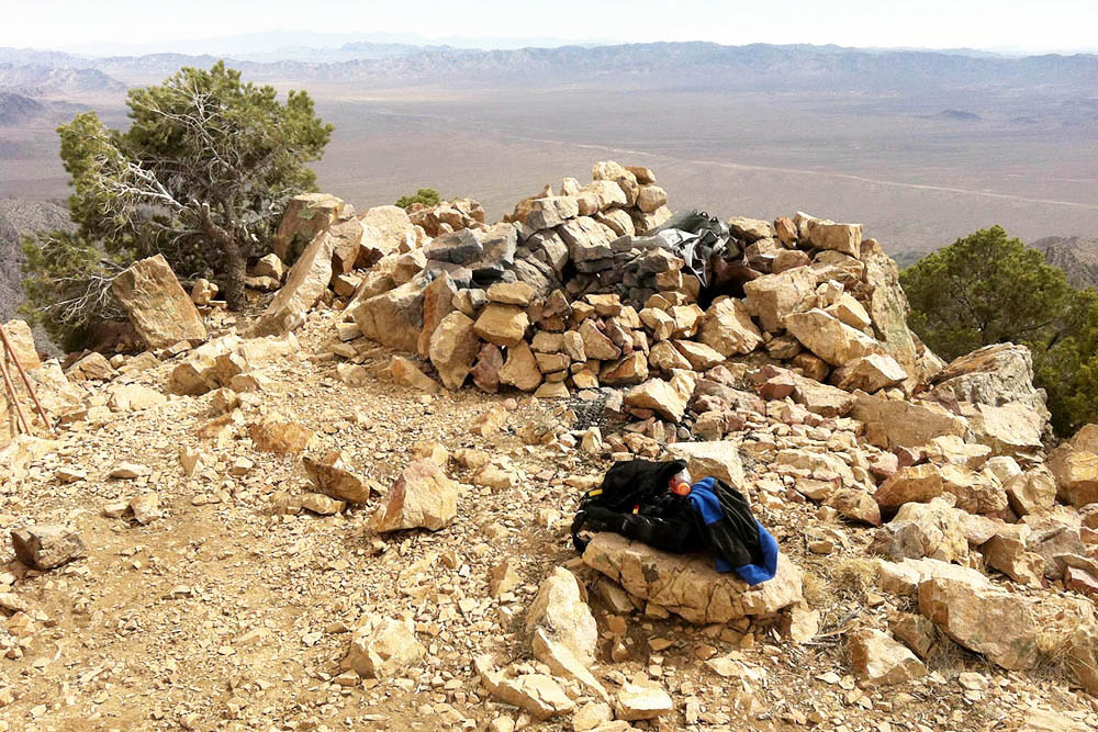
After a short hike to the summit I made my way around the Western rock peak and there it was. The famous observation point someone built with a rock wall where a person can lay down out of the wind and observe the base 26 air miles to the west. I did it. I reached the top.
On this day there was no wind and the temps were mild. Did I get lucky and hike up there on a perfect day?? I striped down and started to enjoy my Gatorade’s. I read on a previous trip report, where it is suppose to be a custom, when someone hikes to the top of Tikaboo that they leave a bottle of water for the next hiker. I had come prepared so I left a Gatorade and a bottle of Dasani.
 I spent about an hour up there looking at the valley below me. With the binos I could easily see the base with it’s buildings and the runway. I was not so interested in the base at this point. I was just feeling so accomplished in myself for making it to the top. After awhile I made a phone call( yes AT&T had service) and surprised my friend Joe.
There was a lot of afternoon haze. If I wanted to take good pictures I would do this trip in the early morning. From the top of Tikaboo you can see for one hundred miles. Groom Lake is only 26 so it seems really close. ( I know..where are the base photos? I’ll save that for the next trip with better camera!!)

37.344166 -115.357871
With friends this would be a really cool trip. I’m not sure about camping on the peak. There is a way better camp area just down the hill in a wooded area about a ten minute hike away. Cover is good and plenty of firewood. I’d use this as my base camp!! I’m more of a truck camper. I have all my gear in my camper shell. Camping at the trail head seems more inviting to me. You can make your own choice.

37.34604, -115.34241
So I high tailed it off the peak and back down the hill. The descent was a bit hard due to the steepness of the last hill. I was amazed that I could even get up this slope. It took roughly 45 minutes til I found my truck again. I walked around the base camp and took in the area for future visits . I fired up my Coleman grill and made a quick dinner. Being at this high altitude is relaxing and I just didn’t want this day to end. But the sun was quickly setting and I wanted to be back on pavement. Until next time…
I want to return again this summer…but now I’m ready to bring friends!!
Dave Budd
All I know is that I was not visited by any Black helicopters or Camo Dudes. I left water for the next hikers and I was nice to the local inhabitants!! I made a phone call and I’m sure I was recorded.It was a great hike and I can’t wait to do it again.
http://www.wrcc.dri.edu/weather/ntik.html
https://photorecon.net/wp-content/uploads/movs/tikaboo.MOV


